- Home
- Departments
- Assessor
- Parcel / Address Search Program
- Property Search Tips
Property Search Tips
Go to Property Search
See below for tips and other information.
Disclaimer & Comments
- Open public records is authorized by the state of Washington RCW 42.56.
- If your searches are not returning results you expect, please check the tips in the following section.
- If Property Search is not displaying properly on your computer, check the Troubleshooting page, and see additional help in the following
- If you still need help, or if you have questions or comments about the data or features of the program, email Pam Rushton.
Tips & Searching / If Property Search returns no results...
Try the Help button on the Property Search page. If the tips there do not help, try entering your search differently, as follows.
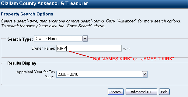 Owner Name Search
When searching by Owner Name, try searching only by the last name. If you search for "James Kirk", it is looking for a record containing the exact phrase "James Kirk". Therefore, if James Kirk is in the system as "James Kirk", it will work. But if he is in the system as "James T Kirk", it will not work. To be sure, if you are searching for James Kirk, enter only "Kirk".
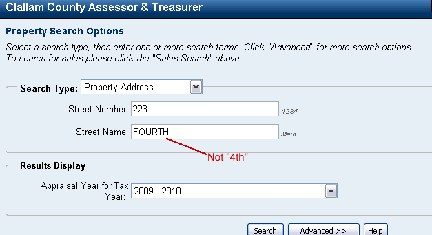 Property Address Search
When searching by Property Address, be sure to enter only the street number in the Street Number field, such as "223", not "223 E 4th". And, in the Street Name field, it must be entered exactly is it is recorded in the system. Numbered streets (16th, etc.) must be spelled out ("Sixteenth"). Street Directions are "N", "S", "E", "W", etc. (don't include a period). If you type "4th" in the street name field, it will return no result if the street is recorded as "Fourth". So, try different variations. Normally, if the street name is a number, it will be recorded as "Fourth" instead of "4th". If the street is a word, try searching the first few characters of the word. Let's say the street is "Fairmount", but it could be recorded as "Fairmont" or "Fairmount". Try entering only the first few characters, such as "Fair". If you search "FAIRMONT" and the address is recorded as "Fairmount", it will return no results. But, if you search "Fair" it will find address with both "Fairmount" and "Fairmont", if both exist. Some street/road names are abbreviated. For instance, "Blue Mountain" is "Blue Mtn" in the Assessor's records. Similar abbreviations are used throughout the County. If an address with a similar type name fails, try an abbreviation. Highway 101 and Highway 112 Addresses should be entered as "HWY 101" or "HWY 112".
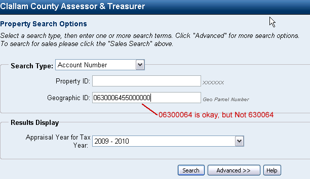 Geographic ID (12 to 16 Digit Geo Parcel Number)
Geographic ID is the Geo Parcel Number. This is a 16-digit field, however, only 12-digits are normally required for the search to work. (The program automatically adds four zeros to the end of 12-digit entries.) Be sure to input any leading zeros. When a 12-digit entry results in "None found", try re-entering the number, then add '1000' or '2001' to the end. When a 16-digit entry results in "None found", try re-entering the first 12-digits only. The program will automatically add four zeros to the end of 12-digit entries.
If the Geo ID has a zero "0" at the beginning, you must enter it. Zeros at the end are not needed. The first few characters must be correct. So, let's say the Geo ID number is 0630006455500000. If you enter "0630006455500000", it will work. If you enter "06300064" it will work, even though you left off the "55500000". However, if you search "630006455500000" (left out the first "0") it will NOT work. The last four-digits of a 16-digit Geographic ID (Geo parcel number) are used to divide a "single lot of record" into multiple tax parcels, where portions of a property are taxed at different rates, or a property has multiple owners who require separate tax records. Note: This process is not a legal subdivision of property. It is for assessment and taxing purposes only. These last four numbers will be '0000' for the most part. Segregated parcels will always have a '1000' record and a corresponding '2001' record. Some parcels are divided even further, indicated by '2002', '2003', etc. Parcel numbers ending with '3000' and above denote special types of property-condo units, boathouses, Reservation lands-that require specific identification for processing purposes. Note, the "Property Number" field is a 5+ digit number and is NOT the parcel number.
For more information contact the Assessor's Office.
Printing & Other Issues
When printing in Property Search, make sure you set the orientation to Landscape in your Print Preferences or setup.
Troubleshooting
If the Property Search page does not load or shows an error message, contact us, let us know what happens when you try the page, and we will communicate with the company that created and supports Property Search.
If the Property Search page loads, but your searches return no results or you have other questions that are not answered on this page, please contact the Assessor's Office.